Despite the important role that Indigenous Peoples and other traditional communities play in managing and safeguarding freshwater resources throughout the Amazon, there is little information aggregated at the basin-scale to illustrate these close relationships and identify gaps and opportunities.
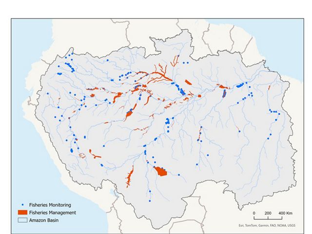
Recognizing this, TNC and partners set out to develop a comprehensive map showcasing ongoing freshwater fisheries management and monitoring initiatives throughout the Amazon River Basin. Fisheries management initiatives generally fall into two categories:
- Formal management areas, often structured as fishing agreements, where community practices are recognized by governmental authorities; and
- Informal management areas where communities manage their resources independently without formal recognition.
Fisheries monitoring refers to the systematic collection of data on fishing activities, including catch composition, effort, gear use, and other key metrics. Further details can be found in the accompanying report, download available below.
The mapping exercise also identifies management areas to target for aquatic connectivity, which is key for healthy and resilient freshwater ecosystem habitats. The focus on connectivity enhances overall effectiveness and helps scale conservation efforts.

As of June 2025, a total of 155 fisheries management initiatives have been identified across four countries in the Amazon region. In total, more than 1,200 communities and 21,000 fishers are involved in fisheries management in the Amazon. These numbers are likely underestimated, given that many locally-managed areas operate without formal recognition, which complicates efforts to gather reliable data about them. As a result, non-formalized Fisheries Management initiatives are likely underreported and underrepresented in this assessment.
In creating the Amazon Fisheries: Mapping Management and Monitoring Initiatives report and map, we are able to streamline our analysis to ideal project sites and potential partners—maximizing conservation outcomes both locally and regionally. This map will be shared with various actors and agencies throughout the Amazon River Basin to promote equitable knowledge exchange. For example, environmental agencies can leverage this information to effectively manage conservation interventions and metrics in a more streamlined, data-driven way.
Mapping for Collaboration
Our goal is to expand local and regional impact through collaborative policies and partnerships, using this new spatial distribution of initiatives to inform strategic management decisions.


